Landowners say bridge closure hurts

Some county residents are not all happy with the Vernon County Commission's decision to close indefinitely a bridge on Talley Bend Road near Moundville.
On Tuesday, the commission -- acting on the recommendation of the Missouri Department of Transportation -- voted to close the bridge known as Bridge Number 63200.5 in Center Township. The bridge is on the township line and located in section 31 of Center Township and section 1 of the Moundville Township.
The commission doesn't know when or even if the bridge will be reopened.

We've been using that bridge for 50 years," said Betty Gray, who with her husband, Robert, lives on property nearest to the bridge on the west side of the creek.
The Grays run cattle on both sides of the creek, so it will really be a problem for them, Mrs. Gray said.
Gary Hogan's residence is nearest the bridge on the east side of the creek.

"It's really not a good deal," Hogan said, "I just wish they'd straighten the bridge out."
Commissioners talked of doing just that several years ago, but easement issues kept the project from going through, according to commissioners.
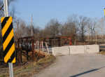
The closure became effective on Tuesday and the bridge has been blocked with signs and barricades. The closure comes at the recommendation of MoDOT which inspected 267 non-state bridges in Vernon County in 2012. According to Construction Inspector Roger Mann, the bridge "has advance section loss and areas with complete section loss on stringers [and] beams, as well as "advance section loss of steel columns" at the south pier.
The bridge is 96 feet long by 14 feet wide and spans Big Drywood Creek. It was built in 1910 and has a traffic load of 50 vehicles per day.
Northern Commissioner Neal Gerster said the county had the option of reducing the load limit of the bridge to three tons or closing it altogether.
"We've chosen to close it on their recommendation," Gerster said adding that reducing the load limit would not keep drivers from crossing the bridge with heavier loads, thereby raising some liability for the county.
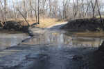
To get around the bridge going north, drivers will have to make a trip of at least three miles. And that will be the shortest route only if the low water crossing on Stokes Road is passable. To get around the bridge to the south, drivers will have to travel at least five miles by an alternate route.
The north detour heads off Talley Bend on 1400 Road, on the east side of the creek, goes west on Stokes and south on 1300 Road to its intersection with Talley Bend on the west side of the creek.
The south detour, stay on BB Highway on the east side of the creek, turn west on F Highway and back north on 1250 Road until it intersects with Talley Bend on the west side of the creek.
The bridge is closed for now and when it will open again is uncertain. The county has its bridge projects for the year already lined out, so it won't be this year, Gerster said.
With spring rains likely to keep the low water crossing on the north detour closed, at least periodically, it will mean longer drives and perhaps longer days for the rural mail carrier and the school bus driver as well as local residents.
